
The Column of Lasting Insignificance: October 20, 2012
by John Wilcock
OREGON DRIVERS must be the most well-behaved in America, this presumably due to an unrealistic statewide speed limit of 55mph, dropping to 25mph at the entrance to most communities. And most drivers stay doggedly on the right, the passing lane favored by out-of-staters many of whom get speeding tickets because state troopers lurk everywhere. Insincere denials are made about California license plates being especially vulnerable.
Of course, this reaping of fees may be the whole point. When I remarked to a gas station attendant that it was all reminiscent of those rip-off speed traps once employed by certain unscrupulous southern states, he responded: “I hear that from two of three people a week.”
Heading north on SR197 from where the highway splits from SR97, there are about 60 miles of largely unoccupied terrain before The Dalles. You may see as many as half a dozen vehicles en route and, you may even ignore the speed limit. But it’s still there — and it’s intimidating, especially for visitors who aren’t used to traveling 55mph for hours at a time.
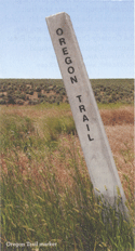
At Tygh Valley if you head west you’ll be following the route of the early pioneers, mid-19th century Oregon Trail voyagers who by then had traveled nearly 2,000 miles and were nearing the end of their journey.
Oregon’s tourist office promotes what’s called the Mount Hood Loop Highway which not only allows close-up views of the 11,249ft snow-capped peak but leads partly over the famous Barlow Road, the last leg of the Oregon Trail. Mount Hood is actually a volcano, which last erupted in 1866, but its potential for a future eruption is considered pretty low.
|
|
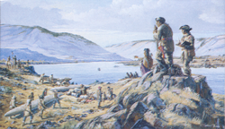
The pioneers along the Oregon Trail, who left Independence, MO, collectively depict one of this nation’s major epics. Prior to 1836, the only routes into Oregon’s fertile Willamette Valley had been laid by trappers and fur traders, traveling on foot or by horseback. Wagon trails were eventually cleared but until 1846 migrants from the east had to make their way up to The Dalles (French for river rapids) and thence via the Columbia River further west. But this excursion by boat was troublesome and expensive, especially with the necessity to take boats out of turbulent stretches of water and portaged along the shore.
In 1845, along came Sam Barlow, 53, a former tailor from Indiana, who after persistent exploration discovered a route through the Cascade Mountains along which wagon trains could pass, successfully petitioning the legislature for permission to build a road. Although his toll was originally assessed at $5 per wagon plus 10c for every horse or head of cattle, the road was never a money-maker, and early in the 1900s, it became irrelevant after construction of the major highway. Meanwhile, the beautiful Willamette Valley became a vintner’s paradise, becoming home to more than 200 wineries and bountiful fruit farms providing apples, pears, and cherries.
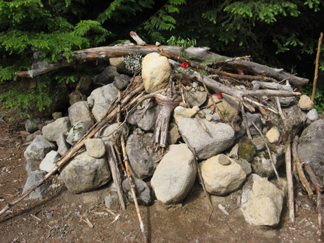
Most of the old Barlow Road has disappeared under SR26 which unpaved portions adjoin, but there are visible ruts beside road 3531 near Bennett’s Pass where the Pioneer Woman’s Grave, piled high with stones and sometimes covered with local wildflowers — white and orange lilies; red paintbrush; purple mission bell — left by hikers, are a touching memorial to the estimated 400,000 settlers, ranchers, farmers, miners, and businessmen and their families who passed this way between 1846 and 1869. An interpretive sign here bears a quote from the son of Steven Coalman, who had been a Barlow Road Superintendent.
“My father remembered meeting a man who had just buried his wife. He buried her in a wagonbox made from the bed of a wagon, and made a crude fence around the grave. She had been very sick, and they had camped there several days before she died. The man had two small children, a boy and a girl, both under five years of age.”
BUT AT TYGH VALLEY, my mission was to continue north on US197 to the Columbia River where at The Dalles I was welcomed by Trooper Mark Jubitz who observed me filling my tank and then followed me for the one-and-one-half blocks to the tourist office, stopping me en route to give me a $110 ticket for not refastening my seat belt. I’ve been driving for half a century in a score of countries but I have never before received such an unjustified citation. Of course, I left The Dalles immediately without further research. If you ever visit, you might want to keep a wary eye open for Trooper Jubitz.
ON OCT 15, 1805, the Merriweather Lewis and William Clark party entered the Columbia River east of The Dalles in canoes hollowed from pine trees. It was at the mouth of the Yakima River which flows into the Columbia. They were received amiably at numerous Indian villages because the presence of a woman with her baby illustrated that they were not a war party, it “confirmed those people of our friendly intentions,” Clark noted. Indians helped with boats, supplies, and food.
“The river is remarkably clear and crowded with salmon in many places.” [The largest — Chinook salmon — average 30lbs and some have been harvested at four times that size. The Columbia is also reputed to have more white sturgeon than any other river in the world. some reaching 1,000lbs in weight.]
TEN DAYS LATER, the party camped above what is now The Dalles from which I-84 and then U.S. 30 hug the river all the way west. Just off the highway, an exhibit in the Columbia Gorge Discovery Center & Museum displays examples of the 30 tons of cargo the intrepid explorers lugged along. [Last week, the Center celebrated “A vintage Evening” with roasted salmon with huckleberry sauce on the menu and wine from local vineyards.]
Soon the expedition encountered their first set of four rapids where “the water of this great river is compressed within the space of 150 paces in which there is a great number of large and small rocks, water passing with great velocity forming and boiling in a most horrible manner.” They were obliged to portage the canoes, sliding them across poles they had laid over the rocks on the slippery river banks.
HOOD RIVER (pop: 7,200) likes to be known as the world’s windsurfing capital, frequented by kiteboarders, sail-boarders, “and other wind mavens.” But it’s currently undergoing what a local paper calls “the great cable debate,” a dispute between locals who want to restrict the boat basin to kayakers and paddle boarders, versus boosters of a cable park. This is described as “a series of cables attached to towers and powered by a motor which allows wakeboarders to be pulled around a body of water and often includes jumps and other terrain features.”
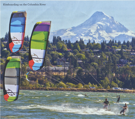
Without the cable, says one backer, “wakeboarding as a sport is boring….it’s like watching paint dry.” A cable park, he declared, makes it a better spectator sport, more of a stadium environment. To which his opponent responded that limiting the boat basin’s use didn’t make sense. “Right now we can all share,” she said.
For some people, thanksgiving is a big time for tofurkey, a casserole of vegetarian protein made from tofu and created here by Turtle Island Foods, a $20m company employing 80 people which began in Seth Tibbott’s home kitchen. Near to the company’s riverfront factory, the Mount Hood Railroad operates daily excursions including variations such as mystery dinner performances, wine tasting, and a staged stand-off between train robbers and the sheriff.
Sadly, I left town one day before a debate staged in the Hood River Library by Mothers Against Misuse and Abuse: Medical Marijuana, what is the science?
A 35-mile drive south from Hood River on SR35 and back on 281 passes 30 farms and wineries on the Fruit Loop Tour. But we head westwards on US 84 paralleling the often unseen river. Oregon, with its multitudinous trees, is a beautiful state and the Columbia River Gap is probably its loveliest part.
BY OCTOBER 22, Clark was negotiating “the great rapids of the Cascades…agitated swelling, boiling and whirling in every direction,” a two-mile stretch which has now been tamed by the Bonneville Dam. Built in 1937 and enlarged in 1981, it pretty much eliminated the need for locks, replaced by the pretty riverside town, Cascade Locks (pop: 1100), which sprang up to help travelers portage around the rapids. Here, the huge Bridge of the Gods replaces one that, according to Indian legend, was built by the gods to span the river. There are daily cruises from the harbor.
The dam, open to visitors and, named after an army captain who charted much of the Oregon Trail, incorporates fish ladders that allow salmon and steelhead to bypass it and head upstream to spawn. Between here and Portland, 40 miles further west, is a region replete with waterfalls. Oregon claims to have 77 of them on its side of the river, categorized typically as a plunge, a block, a tier, segments, punchbowl, cascade, etc.
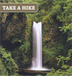
Photo credit: Greg Lief
Almost beside the highway, the 620ft Multnomah Falls is a classic plunge, dropping away from the hillside. Not far away are the self-explanatory Horsetail Falls.
ON NOV 4, 1805, Lewis and Clark camped on an island in the river (they named it Diamond for its shape; it’s now Government Island) where Clark had a bad night: “I could not sleep for the noise kept up by the swans, geese, white and black brants, duck, etc.”
South of the highway, Troutdale, replete with art galleries and eating places, has become a boutique suburb of Portland from which US 30 runs to the coast, not always near the river.
Wappato Island was named by the explorers for its abundance of the fleshy root vegetable which was a staple Indian food and which was a welcome addition to the Lewis and Clark party which had survived largely on elk and fish (although whale blubber was to come). They took several pounds of it along with them.
At the mouth of the Kalamath river, where Clark estimated the main river was more than a mile wide, wooden Indian houses occupied a large stretch of waterfront, and “Seven canoes of Indians came out from this large village to view and trade with us.”
Near journey’s end, on the north bank, almost at the Columbia’s mouth the group was marooned in a small cave for 12 days by atrocious weather “It would be distressing to a feeling person to see our situation at this time, all wet and cold with our bedding also wet.” All through the winter, they survived in the sturdy camp they built at Fort Clatsop, south of Astoria, before starting their journey back home.
[Astoria was the subject of last week’s column]